Ring Laser Gyroscope Two-Axis Indexing Inertial Navigation System-D90C Introduction
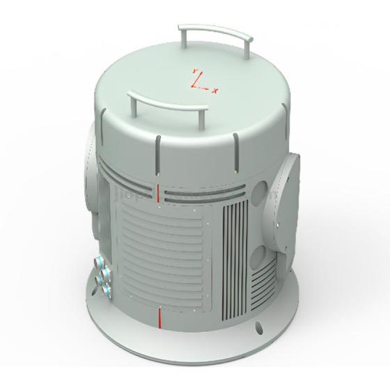
JIO-D90C is an inertial navigation system based on ring laser gyroscope and quartz flexible accelerometer. Can be combined with altimeter, GNSS, airspeed meter and other auxiliary equipment, can provide air carrier, ground carrier and other navigation information, such as speed, position and attitude. D90C series of inertial navigation systems can be widely used in tanks,all kinds of armored vehicles,self-propelled artillery,rockets,all kinds of unmanned aerial vehicles,aircraft,ships,automobiles,high-speed rail,unmanned vehicles, mobile satellite communication systems,drilling and other carrying platforms. Flight control, attitude stabilization,weapon stabilization platform, positioning and positioning, etc.
Technical features
Two-axis indexing mechanism for error mitigationHigh accuracy ring laser gyro and quartz accelerometerOptional static or moving base self-alignmentError parameters calibration and compensation in full temperature rangeOptional diverse input interfaces for GNSS/Odometer/DVLConfigurable navigation modesExcellent environmental suitabilityMilitary standards
Typical application scenarios
Under-sea vehicle navigationPositioning and north-finding for land vehicleStabilization and control for moving carrierAttitude measurement for demanding applications
Main functions of the system
It has the function of outputting information such as carrier position, heading, attitude angle, angular rate and speed in real time;It has working modes such as pure inertial navigation and INS/GNSS (including Beidou) integrated navigation;Possess the function of receiving satellite navigation information provided by external time system frequency standard equipment;It has the function of ground self-alignment and supports the function of air alignment;It has functions such as power-on self-test, periodic self-test, status report, installation error compensation, and non-volatile storage.
System composition and dimensions
The whole system is composed of two parts: the inertial navigation main instrument and the inertial navigation main instrument bracket. Among them, the external dimensions of the main instrument are as follows:
Main technical indicators of the system
| System accuracySystem Accuracy | Pure Inertial Navigation/Pure Inertial Navigation | 2.0nmile/5d, PEAK |
| Integrated Navigation/Navigation with GNSS | ≤5m , 1σ _ |
| Heading angle /Heading | 0.01°, RMS |
| Horizontal attitude (roll and pitch )Horizontal Attitude (roll & pitch) | 0.005°, RMS |
| Pure Inertial Velocity | 1m/s , RMS |
| GNSS Integrated navigation Velocity | 0. 1 m/s , RMS |
| Indicators of inertial devices Gyro and Accelerometer Parameters | laser gyroscope _Gyroscope | Range/Range | ± 6 00 deg/s |
| Bias Stability | ≤0.02 deg/h, 1σ |
| Zero bias repeatabilityBias Repeatability | ≤0.02 deg/h, 1σ |
| Scale Factor non-linearity | 1 ppm |
| AccelerometerAccelerometer | Range/Range | ± 15g _ |
| Bias Stability | ≤10μg , 1σ |
| Zero bias repeatabilityBias Repeatability | ≤10μg , 1σ |
| Scale Factor non-linearity | 15 ppm |
| align time Alignment Time | Cold Start | ≤ 10 min |
| Re-Start | ≤15min |
| Air/In-Flight Start | more than 10h |
| Interface Features interface | Supply voltage/Voltage | 18~36VDC |
| Power Consumption | ≤ 40W @ 24VDC |
| Electrical interface/Electrical | RS232 × 2RS422 × 3CAN × 2Ethernet × 11pps × 1 |
| Data Update Rate (configurable) | 200Hz 115.2kbps _ _ _ |
| Use environment Environmental | Operating Temperature | -40°C~+65°C |
| Storage temperature/Storage Temperature | -55°C~+85°C |
| Use Altitude/Altitude | 20000m |
| Humidity | 95% (+25°C) |
| Vibration/Vibration | 5g @ 20~2000Hz |
| Shock/Shock | 40 g, 11 ms, 1/2 Sine |
| Physical properties Physical | Dimensions/ Size (L*W*H) | 540 x 536mm _ |
| Weight/ Weight | 55 kg |
Note: The structure can be customized according to the user's requirements.













Clients Reviews